
Goddard Space Flight Center, Greenbelt, Maryland 20771
ENGINEERING COLLOQUIUM
Monday, May 7, 2018 / 3:30 PM, Building 3 Auditorium
Bruce Cook
"G-LiHT v2.0: The Next Generation of NASA Goddard’s LiDAR, Hyperspectral, and Thermal Airborne Imager"
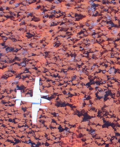
ABSTRACT -- G-LiHT is a portable, airborne imaging system that simultaneously maps the composition, structure, and function of terrestrial ecosystems using:
- a scanning LiDAR to provide 3D information about the distribution of foliage and canopy elements;
- imaging spectroscopy to discern species composition and variations in biophysical variables;
- thermal measurements to quantify surface temperatures and detect heat and moisture stress;
- a stereo RGB camera to identify fine scale (~3 cm) canopy features; and
- a fine spectral-resolution (<0.2 nm) spectrometer for retrieving solar-induced fluorescence from chlorophyll.
G-LiHT enables data fusion studies by providing coincident data in time and space, and provides fine-scale (<1 m) observations over large areas that are needed in many ecosystem studies. Initially designed during 2011, the next generation G-LiHT was designed and assembled in 2017 with new and upgraded commercial-off-the-shelf instruments. During the past 7 years, G-LiHT has acquired >1000 hours of science data ranging from tropical forests in Belize to high-latitude regions in Alaska, addressing a broad range of science questions related to ecosystem form and function. G-LiHT campaigns this year will target post-hurricane damage in Puerto Rico; forest pest outbreaks in the western US; and a first ever USFS forest inventory in interior Alaska. G-LiHT data products are openly available through a novel, user-friend web interface, which has contributed to new science within and outside the field of plant and ecosystem science, including the discovery of anthropogenic Pre-Columbian features in Mexico.
SPEAKER -- Dr. Bruce Cook is a Physical Scientist in the Biospheric Sciences Laboratory who studies ecosystem form and function in uplands and wetlands using LiDAR and multi-sensor remote sensing. His research interests include photosynthesis and plant production; disturbance and plant succession; nutrient cycling; and ecosystem-atmosphere exchange of CO2, CH4, heat and water vapor. He is Deputy Project Scientist for Landsat 9, and Principal Investigator of NASA Goddard’s LiDAR, Hyperspectral, and Thermal (G-LiHT) airborne imager (http://gliht.gsfc.nasa.gov/).
Colloquium Committee Sponsor: Vanessa Thomas
Engineering Colloquium home page: https://ecolloq.gsfc.nasa.gov